

Tornado Threat Tonight: Minnesota Storm Timing and Impact
UPDATE: Possible Super Cell Development Prompts Tornado Watch For Region
Residents across central and southeast Minnesota and western Wisconsin should prepare for significant severe weather this evening. The National Weather Service in La Crosse has issued a high-level alert, warning that widespread severe storms are likely.
Widespread Severe Storms Likely Across Minnesota
NWS has placed much of the region under a Level 4 out of 5 severe weather threat, currently the highest local risk for dangerous storms.
READ MORE: Celebrity Lives in the Middle of Nowhere in Minnesota and Loves It
The greatest concern centers along and near the Interstate 90 corridor, impacting Rochester, La Crosse, and surrounding areas. The Twin Cities, Mankato, and Albert Lea, Faribault, and Owatonna are also included in the highest risk area. Forecasters emphasize that severe storms are not just possible but likely.

Primary Threats With Severe Storms Monday
Monday's storms have the potential to produce multiple hazards. NWS says the main threats include large hail, damaging winds, and the possibility of tornadoes, with a few strong tornadoes not ruled out. There is a 60 percent chance of severe storm development this evening, with a concentration of stronger storms expected, particularly north of I-90 in Minnesota and Wisconsin.
Timing: When Storms Are Expected to Arrive (UPDATED)
Two rounds of severe storms are expected today, with the most dangerous activity arriving this evening.
Round one will develop between 1 p.m. and 6 p.m., mainly impacting northeast Iowa and parts of southwest and central Wisconsin.
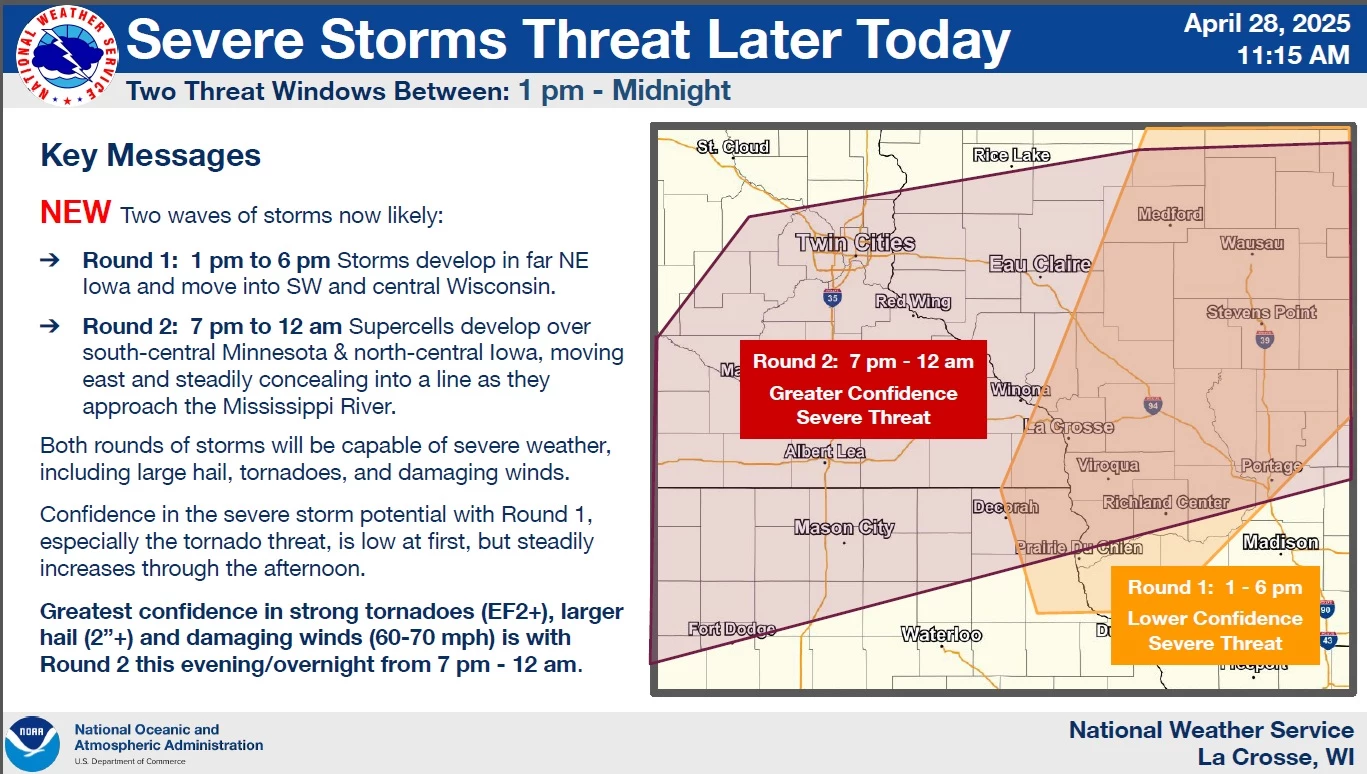
Round two will be the primary concern, with supercells expected to form over south-central Minnesota and north-central Iowa between 4 p.m. and 7 p.m.
These storms will move eastward, intensifying and organizing into a line as they push toward southeastern Minnesota and western Wisconsin.
The greatest threat for strong tornadoes, large hail, and damaging winds will occur between 7 p.m. and midnight, with storms reaching the Mississippi River between 10 p.m. and 11 p.m.

The National Weather Service urges everyone to stay weather aware as conditions develop. People should be prepared to take shelter indoors quickly if warnings are issued. It is important to have several reliable ways to receive weather alerts, such as weather radios, mobile apps, or local news. Those with outdoor plans tonight are strongly encouraged to reconsider or ensure they have immediate access to shelter.

In the event of an approaching tornado, NWS shared the following information about where you should go:

11 of the Most Devastating Weather Disasters in Minnesota Throughout The Years
Gallery Credit: Jessica Williams
More From Minnesota Now


