

NWS: Storms Could Bring Up To 4-6+ Inches Of Rain To Parts Of The Northland
The Duluth office of the National Weather Service is watching a notable risk of heavy rain today (Tuesday) and tomorrow (Wednesday) that brings with it flooding risks.
Heavy rain and storms are bringing a widespread chance of 1-3 inches of rain to a good share of the Northland, with some localized areas possibly seeing 4-6 or more inches of rain during this storm event.
While there is a pretty decent likelihood of heavy rain in the region, where the heaviest rain falls is not completely certain as of the Tuesday morning update from the Duluth office of the National Weather Service.
In that update, they place the Twin Ports area in a 5-15% chance of seeing flash flooding from this storm system Tuesday night and Wednesday. The Iron Range sees that same percentage chance just for Tuesday, while areas to the south see greater chances.

So, how much rain could actually fall? Where will the heaviest rain fall?
As I mentioned, the experts are saying there is still uncertainty with that, but weather models have been suggesting the heaviest rain will fall through Central Minnesota, with different models offering different ideas of what might happen. Here are a couple of examples.
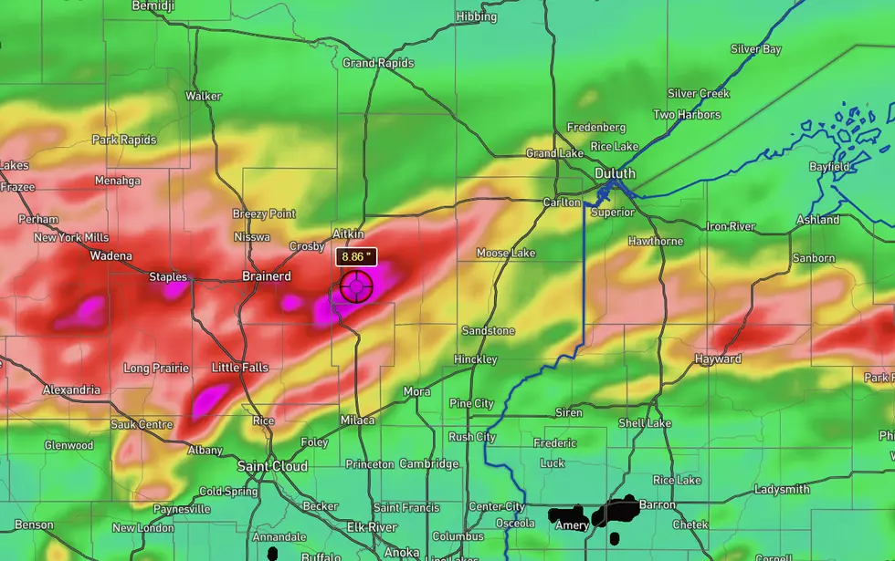
One of the more dramatic models (seen above) shows a band of nearly 9 inches of rain in the area of Mille Lacs Lake, with Brainerd seeing between 6 and 8 inches, and 3-4 inches of rain from that heavy band extending up to near Cromwell.
READ MORE: Munger Trail In Duluth Reopened After Restoration Project
The same model suggests the Twin Ports area would see about an inch of rain, with places like Gordon and Solon Springs projected to get around 4 inches, and between Hayward and Cable around 6 inches.

Another model shows lesser, but still significant overall amounts of rain, with the heaviest area shifted a bit eastward, centered in the area between Askov and Gordon along the Minnesota-Wisconsin border. In this model's bullseye, rain amounts are projected to be between 3 and 4 inches.
The Brainerd area and places westward in this model could see 2-3 inches of rain, with the Twin Ports area seeing less than an inch.

We'll see what actually happens as the storms roll through Tuesday evening and into Wednesday.
Regardless of where the heaviest rain falls, the National Weather Service is reminding everyone to be safe. Knowing how deep the water really is on a flooded roadway can be very difficult to judge, and this can be made worse by washouts under the water you might not be able to see.
As the saying goes, "turn around, don't drown". Traveling on a roadway can be very dangerous.
Rain is expected to wrap up through the day Wednesday across the Northland, with drier weather in the forecast for the end of the week.
Historic Derechos In Minnesota Weather History
Gallery Credit: Nick Cooper